History
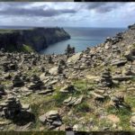
The Vanoise National Park was France’s first national park created in 1963 covering an area of 520 sq km. The culminating point of the Vanoise is the Grand Casse which rises to 3855m which was first climbed by William Matthews in 1860. The Park shares a 15km common boundary with the Grand Paradiso National Park in Italy. There are over 107 summits that exceed 3000m. The Vanoise, located in the department of Savoie, stretch from the border with Italy just beyond Val d’Is?re and Bonneval-sur-Arc to the Col de la Madeleine bounded by the valleys of the Tarentaise and Maurienne. The Savoie department formed part of the independent kingdom of Savoie Sardaigne that only became part of France in 1860. Savoie’s administrative centre is located in Chamb?ry.
The Vanoise National Park remain unspoilt due to strict controls on construction and development.
The Tour
The route described here is sometimes known as the Tour des Glaciers de la Vanoise.
One of the great beauties of this tour, apart from the superb scenery, is that you don’t drop down to a valley again until the end of the tour. Likewise you will not pass through villages, and walk close to roads. Having said this the tour is well provided with mountain refuges that provide simple accommodation and where you meet like-minded people.s
It is, in my opinion, a better tour than the one described passing through the village of Val d’Is?re and Tignes with the cancerous protuberances of the ski industry. Compared with the Tour du Mont Blanc you stay at altitude during the whole tour and need only touch tarmac road for 50m from start to finish.
There’s a choice of natural starting points, either Pralognan-la-Vanoise, (accessible from Moutiers in the Tarentaise valley) or Modane (in the Maurienne Valley). The route I will describe starts from Pralognan-la-Vanoise.
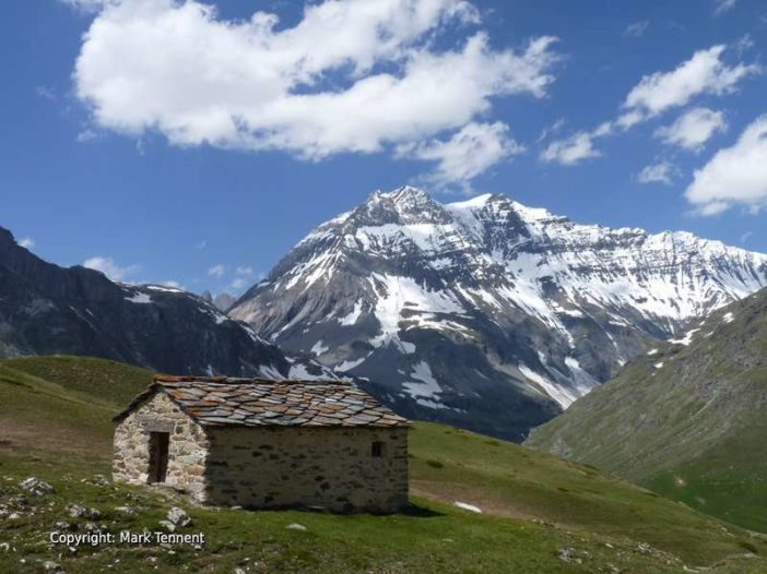
If you take the route in a clock-wise direction the first day is a gentle one that leads via the Lac des Vaches to the Col de la Vanoise; at the foot of the Grande Casse. The route follows the ancient ?Route du Sel?; an old trading route going back 100’s of years. The col, with the refuge Felix Faure, makes a wonderful spot to spend the night. The marmottes here are particularly friendly. If you have energy to spare you can explore the area around the col and perhaps walk up to the edge of the glacier.
The path now heads past Lac Bond and the Lac du Col de la Vanoise, only losing a little height, before contouring right around the hillside. There’s a junction here with the path to Entre deux Eaux and a road to Termignon in the Maurienne. The path climbs gently but in general it follows a natural balcony passing below the glacier de Pelve above and the deep gorge of the Doron du Termignon. The views to the south are outstanding, a panorama of mountains that form the Italian frontier. The only road across this range passes over the Col de Mont Cenis. Soon the Arpont refuge comes into sight, built into the moraine and thus protected from avalanches.
The journey continues high above the Maurienne crossing tumbling streams on the steep flanks of the mountains below the Dent Parrachee. The shepherd’s huts of La Loza perched on a spur are passed before a zig-zag descent crossing some steep ravines brings us out above the village of Aussois. Here two lakes, the Plan d’Amont (higher) and the Plan d’Aval (lower) provide hydro-electric power. A few ski lifts make their appearance as the national park’s boundary bends inwards. There’s a choice of refuges, Plan Sec, La Dent Parrachee or the Fond d’Aussois. Take your pick but I like the traditional, rustic, Dent Parrachee with Franck the friendly guardian.
Today’s ?normal route? crosses over the valley and passes via the Col Barbier (2287m) sharing the line of the GR5 on it’s journey south, before traversing more alpine pastures. Be aware of the ?patous? who may be guarding the herds of sheep (the best advice is to stop and wait for them to see that you are not a threat and then to move slowly). The route now drops down through pine woods and passes through the edge of a boulder field before regaining height to reach the L’Orgere. Here there’s the first sight of tarmac since leaving Pralognan-la-Vanoise and a chance for a bit more comfort if you wish. For those wanting more of a challenge you can take the ?direct? route via the Col de la Masse (2923m) with an equally challenging, for the knees, descent to the l’Org?re. This area is often frequented by chamois.
The next section climbs in a few zig-zags above l’Orgere before easing off and eventually passing the lac de la Partie. Above and to the left is the Aiguille Polset and the Glacier de G?broulaz however the route makes for the natural crossing point, the Col de la Chaviere (2796m), the highest ?obligatory? col on any GR in France. A short steep descent on loose ground leads to a meandering route through old moraine and boulder fields. Soon the refuge Peclet-Polset is reached, a very modern refuge, the old one burned down in a fire. If you want a little more exercise you can reach the Lac Blanc in about 15 mins from here.
The valley that extends below is the start of the Doron and soon you are amongst the pastures again on a well-defined track. Make a choice at the farm of Le Ritort either to carry on in the valley bottom or you can climb up and traverse below the Glacier de Genepy before regaining the valley floor near the hamlet of Prioux. Here the tarmac commences again but leave the end of the hamlet and walk down the left-hand bank to reach the road that’s crossed to immediately to follow a track all the way to Pralognan-la-Vanoise, and the end of the Tour.
Wildlife
Keep your eyes peeled for the relatively rare Bearded Vulture (Gypaete Barbu) with it’s wingspan approaching 3m! It feeds on carrion so is one of nature’s recyclers! It has the habit of dropping large bones from altitude to smash them open on rocks. There is a pair nesting not far from Peisey-Nancroix and the vultures have a territory of between 100 and 700 km2.
The park is famous for its large population of Bouquetin (Ibex) who were almost hunted to extinction. Now there’s approaching 4000 and they are relatively approachable. The males are identified most easily by their large, almost 1m long, scimitar shaped, knobbly horns. The females have shorter horns that are less ?knobbly?.
Chamois (Rupicapra rupicapra) are highly agile and have hooves adapted to their preferred terrain of steep rocky ground where they feel safe from the threat of two-legged hunters. They have a white ?blaze? on their cheeks and short horns that curve just at the top. If you’re lucky you may see a young chamois (cabri) with it’s mother.
You will undoubtedly encounter the cuddly looking Marmotte but your first awareness of it’s presence is likely to be a shrill whistle. This whistle is their warning cry to alert other members of their group that there’s a threat. The nature of the whistle changes to reflect whether it’s a ground or aerial threat.
Flowers
Wild flowers are probably at their best in June and early July. This depends on how quickly the winter snows melt. Keep your eyes open for the iconic edelweiss and the g?n?py that gives it’s name to the pale-ish liqueur. Naturally you should come across the stunningly beautiful blue gentiane. Please note that in the Vanoise National Park that picking the flowers is forbidden.
When
The main limiting factor is availability of the mountain huts (refuges); the second, in the spring, being the snow remaining from the winter. The refuges normally open around mid-June (exact dates can be found on www.refuges-vanoise.com and they typically close in mid-September despite the weather often being good at this time of year.
Equipment
You should only require ?normal? mountain walking attire plus a sheet sleeping bag for using in the refuges. You can read an article here on staying in mountain refuges (Link to Simply Savoie).
Getting there:
The principle airports are Lyon, Geneva (in Switzerland), Grenoble. Chamb?ry’s airport is principally a winter point of entry for skiers flocking to the ski resorts.
By rail the TGV gets you quickly to Chamb?ry (only 2hrs 30 from Paris) and then you can easily get to either Modane or Moutiers. From Moutiers buses or taxis are available to Pralognan-la-Vanoise.