The winter traverse of the Chartreuse mountains is a marvellous way to explore an area that retains an authentic charm. Bypassed by the masses the Chartreuse keeps it’s charms for those that want to distance themselves from the madding crowd. Silence, time for contemplation, moments to reflect, a breath of fresh air. Take the first step.

The Chartreuse mountains are located in South-East France between the city of Grenoble in the south and the Lac du Bourget, between Chambery and Aix-les-Bains in the north. The eastern edge of the range is delimited by the river Isere. To the south the river cuts through a gap between Grenoble and Voiron and this forms the southern limit of the range. The Chartreuse has more than 1300km of marked footpaths ranging from gentle strolls to the long-distance paths of the Tour de Chartreuse and the Traverse of the Chartreuse.
The Chartreuse were classed as a Natural Regional Park in 1995 and the park covers an area of 76700 hectares overlapping the departments of Isere and Savoie. The highest point is the summit of the Chamechaud, 2082m. ?Les Hauts de Chartreuse? (the ?High Chartreuse?) are characterised by cliff fringed mountains with the lower slopes covered in extensive forests. These are the home to roe deer, wild boar, red deer, mouflons and chamois. Ibex were re-introduced in 2010 and there are currently around 30 individuals at the time of writing mainly in the area of Le Granier. It is a nature reserve with restrictions in place to protect the flora, fauna and natural environment.
The Chartreuse was the scene of a natural disaster in 1248 when the north face of the Granier (1933m) collapsed. The enormous landslip caused the death of between 4000 and 6000 people. Some of the boulders, of several 100 m3 travelled distances of around 8km from the cliff. Remnants of this catastrophy can still be seen amongst the vineyards of les Abymes near the Lac Saint-Andre.

The Chartreuse are famous for the liqueur of the same name originally produced by the monks of the Monastery of the Grande Chartreuse. The monks are from the Carthusian Order which was founded by St Bruno in 1084. The ?green? Chartreuse is strong 55% and is composed of alcohol, sugar and a close-guarded secret composition of 130 plants and flowers! It is typically drunk as a ?digestif?. In 2014 this liqueur will have celebrated 250 years of existence. It’s not possible to visit the monastery itself but at La Correrie, at the entrance to the valley, there’s a museum open to the public
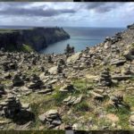
The Chartreuse is a predominantly limestone massif that forms part of the French Prealps. During the formation of the Alps, starting around 30 million years ago, the rocky layers were folded and raised up. Erosion only left the bottom of the fold in the form of a long gutter (perched syncline), oriented North-South. The Chartreuse are typified by the steep limestone cliffs, high plateau and deep, wooded valleys. The Chartreuse is a ?gruyere? with extensive cave systems; over 250km have been discovered. In 1988 the bones of cave bears (Ursus Spelaeus) were discovered in a cave at la Balme-?-Collomb part of Le Granier.
The Traverse
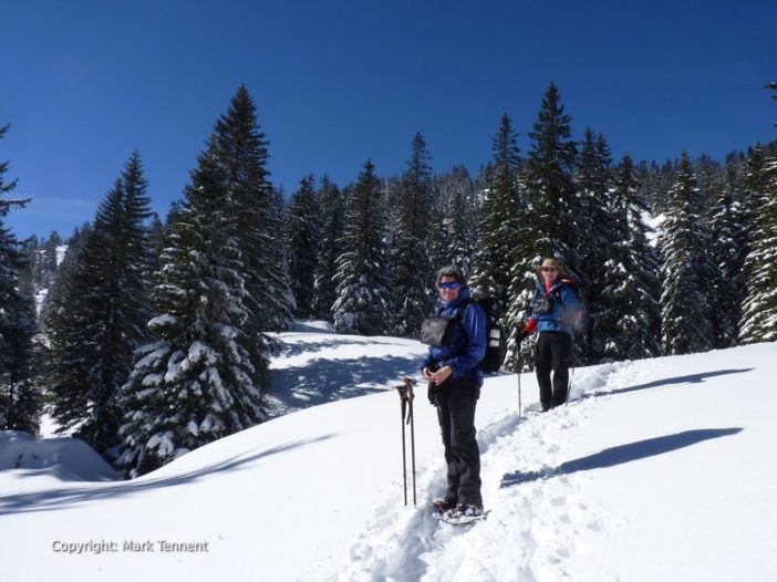
In the winter the high plateau are relatively inaccessible and the lack of refuges or other accommodation means one has to descend to the villages and hamlets. In addition the ?karst? limestone hides deep clefts and pot holes that can be a serious hazard hidden by the snow. The traverse thus goes from village to village crossing passes with the possibility of taking in a few of the more accessible summits.
The traverse is probably best done South-North and leaving a vehicle in Chambery. The start can be reached easily from Grenoble by taxi. The longest days walking is around 7 hours with stages typically being in the 5 ? 6 hour range. The itinerary described gives six days walking.
Leaving from Sarcenas walking through snow-covered fields allows you to gain a path that leads up through forest to a ridge running between La Pinea and Montfromage (1662m). A loop back down brings you to the Col de Porte (1326m) and the possibility of overnight accommodation in the shadow of the Chamechaud.
From the Col de Porte a small road, closed in winter by snow, leads gently but steadily up to the alpine pastures below the Charmant Som (1867 m). Arriving at the pastures gives extensive views of the Chartreuse. A small ?oratoire? welcomes you to this point. A broad ridge leads to the Chalets de Charmant Som. The way to the summit steepens up a spur that leads eventually to the summit of the Charmant Som, a stunning viewpoint of the onward journey. In summer the GR takes a descending traverse across the eastern face of the mountain but in winter this is not advised (the route crossing steep limestone slabs). The best way is to retrace steps and to take the approximate line of a summer path that starts near the Oratoire. Alternatively descending the line of the route to the Col de Porte a broad, gully clear of trees can be used to link up with the former path and the hamlet of les Cottaves. Here contouring through fields brings you to Les Revols and the continuing path through pine woods. A final track leads down through occasional dwellings to Le Diat. From here a short walk leads to the centre of St Pierre en Chartreuse with a range of shops and choices of accommodation.
A brief walk along the side of the Guiers Mort river allows one to gain a path that leads directly to La Correrie where, except in winter, there’s a museum related to the monastery. A tree-lined road flanked by open fields now leads to the imposing monastery of the Grande Chartreuse. The way on offers to reach the Col de la Ruchere (1407m). Above you is the Petit Som and behind the Grand Som. The onward path descends through mixed woodland to the hamlet of La Ruchere which includes a small nordic skiing area. Accommodation is available in this dispersed hamlet.
Leaving La Ruchere a break in the trees leads to a track that gains a weakness in the barring cliffs. This gives access to a ?hidden? valley where a gentle climb brings you out on to the Col de Lechaud (1704m). The Petit Som is to the right and the Grand Som to the left. A short rising traverse allows you to pass through a cleft in the small ridge which gives access to open slopes with sparse pines that bring you to the Col Bovinant (1646m). A long valley flanked on the right by imposing limestone cliffs wends its way down through woods to reach the hamlet of Le Chateau with it’s ancient ruined castle standing guard over the village of St Pierre d’Entremont. A peculiarity of this village is that it’s in fact split in two! There’s St Pierre d’Entremont (Savoie) and St Pierre d’Entremont (Isere). A range of services are available.
A path leads from the centre of the village, first crossing the river, and leads up through a number of small hamlets. The route now contours through fields below the forested slopes of the imposing ramparts of Le Pinet (1867m) that guard the high plateau above. Finally, to reach the cirque de la Plagne an unmarked path through the forest allows you to gain a forestry track. Soon you arrive at the little hamlet of La Plagne, hemmed in by the cliffs above. If you look carefully on the steep slopes below the cliffs you may see ibex or chamois. La Plagne is a starting point to gain the high plateau via the Col de l’Alpette.
Quitting La Plagne it’s possible to contour around to join the small hamlet of Tencovaz after having passed above that of Le Granier. The onward journey crosses the road that leads to the Col de Granier before passing through the hamlet of La Coche. Now a stream is crossed before climbing up through woods and open fields to the Granges de Joigny. Soon the path heads up through beechwoods to the Pointe de Gorgeat (1486m). Here a view opens out over Chambery and beyond to the Lac du Bourget, France’s largest natural lake flanked on the left by the ridge of L’Epine and the Dent du Chat. Chambery beckons! Down along the crest of the ridge before quitting it at the Passage de la Coche to join fields and eventually the outskirts of Chambery near the Museum to Jean-Jacques Rousseau. A flight of steps leads down to the Carre Curial, a Napoleonic barracks, and the Maison des Parcs et de la Montagne. A sense of satisfaction tinged with sadness after having spent the last few days amongst the timeless beauty of the mountains ? the traverse over.
Take time to visit the permanent exhibition on the Vanoise National Park and the Bauges & Chartreuse Regional Parks in the Maison des Parcs et de la Montagne (now sadly closed). Linger a while in the old medieval streets of Chambery, home of the Dukes of Savoie and the capital of the old Kingdom of Savoie-Sardaigne that finally attached itself to France by the Treaty of Turin in 1860. Savour the market on Saturday morning close to the Hotel de Ville and draw in the enticing smells of Denis Provent’s, cheese shop who supplies many of the top hotels and restaurants in the region
Practical Information
When
In winter there are no guardianed refuges on the high plateau. One is therefore obliged to use accommodation in the hamlets and villages of the massif. Check this out in advance to avoid potential difficulties.
Due to the comparatively low altitude of the Chartreuse the snowiest months are likely to be January, February and early March.
Equipment
Snowshoes and walking poles (with snow baskets) of course. Given the nature of some parts of the traverse serious consideration should be given to wearing avalanche transceivers and carrying a snow shovel and avalanche probes. Don’t forget to practise using them!
Getting there:
The principle airports in the region are Lyon, Geneva (in Switzerland), Grenoble. Chamb?ry’s airport is principally a winter point of entry for skiers flocking to the ski resorts.
By rail the high speed train or ?TGV? gets you quickly to Chamb?ry (only 2hrs 30 from Paris) or Grenoble.